Most racing cyclists like to talk about the best climbs in their area. There are books and newspaper articles a plenty about them: which is best, which is hardest, which is the steepest etc. Few racing cyclists like to compare the flatter roads they ride along, perhaps justifiably, they can be a bit boring. But in Wales there are 2 roads that vastly underrated because they dont hit the high percentages of the Gospel Pass or Black Mountain. Lets celebrate them here.
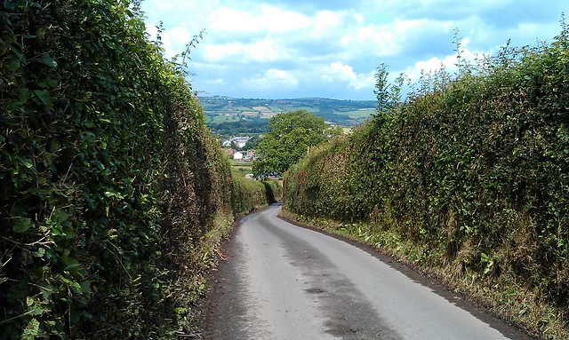
1. Sarn Helen: Ystradfellte to Heol Senni
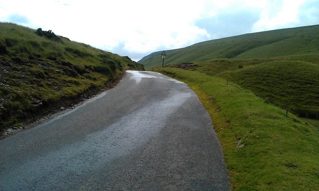
Just to clarify, by flat roads I didnt mean that they had to be completely flat, nor that you might have to do some climbing to get them. Sarn Helen is a case in point.
The climb starts at Aberllia which you can get to via Pontneddfechan or the Penderyn road. Looking at the OS map, the two arrows indicate steepness, but its not that bad. Once at the cattle grid, prepare for some breathtaking scenery.
Its difficult to know which way to look: backwards, sideways or onwards. The road gradually climbs up through this glacial landscape, but only approaching a climb towards the top. Looking back you can see the Neath valley, to the side the stream and the Bronze age obelisk and the steep sided U-shaped valley. Then once at the top of the red sandstone escarpment, the view onto Defynnog is stunning, either from the top, the bottom or halfway. Just watch out for the sheep as you descend.
View Larger Map
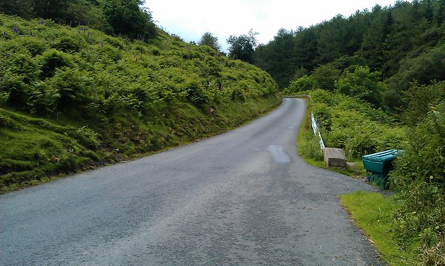
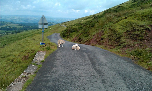
2. Rhayader to Cwmystywth
Another road with a climb to start with, but its not the climb that's of note, but the scenary once on top. The road twists and turns along side a rock strewn barren landscape. There's no steep valley sides to protect from the wind: its a real moonscape. After a while of this you suddenly plunge into a lush green valley only to come across a derelict former lead mine.
View Larger Map
Sunday, 22 July 2012
Monday, 16 July 2012
The Gospel Pass: Wales' Highest Road
Where's the highest road in Wales? The most common answer you'll hear is the Bwlch-y-Groes, up near Bala in North Wales. This is wrong. The answer is in fact the Gospel Pass, a narrow road from Hay-on-Wye to Abergavenny. The Gospel Pass tops out around 551m and the Bwlch-y-Groes around 544m depending on where you look (the altitudes vary on Strava and OS maps).
One wonders why this mistake is made so often? Is it because there's always something strange about the kinds of borderlands that the Gospel Pass finds itself in? Never quite in England, the road flirts with Englishness as it climbs up to Lord Herefordshire's Knob. It even starts out in the "independent" state of Hay-on-Wye. Perhaps its this not quite Welsh, not quite English status that leads many to overlook it in favour of the much more Welsh sounding Bwlch-y-Groes. After all, its in North Wales, it must be hilly up there, right?
The two climbs differ in other respects. The southern side of the Bwlch-y-Groes is horrendously steep. Littered with arrows on OS maps, symbols that tell most sane cyclists: find another road. But it is quite short: just 2.5km but with an average gradient of 13.5%. Vertically you climb 356m.
The Gospel Pass is a different animal. Longer, higher and shallower. At just over 5 miles, the climb is an average of 5.5% - equivalent to some of the other classic climbs in South Wales such as the Bwlch and Rhigos. Vertically it climbs 456 metres - only just surpassed by the longer Machynlleth mountain road.
But the gradient on the Gospel pass constantly changes, lots of up, some flat and even some down. Its hard to pace your effort, and the variation means there are some steep sections unlike the constant gradients of say the Rhigos.

An innocuous start...
The climb divides neatly into three sections. The first might be considered undulating rather than a serious climb. Leaving the junction in Hay, the road begins climbing gradually, pitching up past a dairy farm where the road surface is poor, before settling down into an uneven rhythm. A downhill section around a hairpin has you wondering whether this road really is going uphill, before a short steep pitch reminds you that it is.
One of the early steep sections, but not really climbing yet
There is no real view of where you are headed and another flat section sows more doubt that you are going the wrong way. Its confusing - this is the borderlands, remember. But then you reach the corner, and things start to become clear.

The Corner...
The corner marks the start of the second section of the climb. This is the steepest section that takes you out on to the common. There's not much to say about this section: its steep and hard. There are a couple of cattle grids, and if it has been raining the road will be slippery making climbing out of the saddle tricky.
Steep bits
Slowly, the foxgloves and ferns on the side of the road begin to make way for a more desolate landscape which marks the start of the third stage. By now most of the clmbing is done.
The pass snaking its way up. On the right, Lord Herefordshire's Knob...
There are a couple of short steep sections to come, but once onto the common the rest of the road can be seen snaking away to the summit. If the road isnt too obstructed by sheep, then this section can be taken in the big ring. Until the very top, where the final 500 metres reminds you that you have been riding over Wales' highest road.
The top...
The descent - either back down to Hay or on to Capel y Ffin - is extremely technical and dangerous: its a single track road with walkers, cars and sheep to avoid. Best stop and take photos on the way down like I did, rather than think its the Tour de France.
Take care on the descent...
And that's the Gospel Pass: an ambiguous climb, but all the more interesting for it.
One wonders why this mistake is made so often? Is it because there's always something strange about the kinds of borderlands that the Gospel Pass finds itself in? Never quite in England, the road flirts with Englishness as it climbs up to Lord Herefordshire's Knob. It even starts out in the "independent" state of Hay-on-Wye. Perhaps its this not quite Welsh, not quite English status that leads many to overlook it in favour of the much more Welsh sounding Bwlch-y-Groes. After all, its in North Wales, it must be hilly up there, right?
The two climbs differ in other respects. The southern side of the Bwlch-y-Groes is horrendously steep. Littered with arrows on OS maps, symbols that tell most sane cyclists: find another road. But it is quite short: just 2.5km but with an average gradient of 13.5%. Vertically you climb 356m.
The Gospel Pass is a different animal. Longer, higher and shallower. At just over 5 miles, the climb is an average of 5.5% - equivalent to some of the other classic climbs in South Wales such as the Bwlch and Rhigos. Vertically it climbs 456 metres - only just surpassed by the longer Machynlleth mountain road.
But the gradient on the Gospel pass constantly changes, lots of up, some flat and even some down. Its hard to pace your effort, and the variation means there are some steep sections unlike the constant gradients of say the Rhigos.
An innocuous start...
The climb divides neatly into three sections. The first might be considered undulating rather than a serious climb. Leaving the junction in Hay, the road begins climbing gradually, pitching up past a dairy farm where the road surface is poor, before settling down into an uneven rhythm. A downhill section around a hairpin has you wondering whether this road really is going uphill, before a short steep pitch reminds you that it is.
One of the early steep sections, but not really climbing yet
There is no real view of where you are headed and another flat section sows more doubt that you are going the wrong way. Its confusing - this is the borderlands, remember. But then you reach the corner, and things start to become clear.
The Corner...
The corner marks the start of the second section of the climb. This is the steepest section that takes you out on to the common. There's not much to say about this section: its steep and hard. There are a couple of cattle grids, and if it has been raining the road will be slippery making climbing out of the saddle tricky.
Steep bits
Slowly, the foxgloves and ferns on the side of the road begin to make way for a more desolate landscape which marks the start of the third stage. By now most of the clmbing is done.
The pass snaking its way up. On the right, Lord Herefordshire's Knob...
There are a couple of short steep sections to come, but once onto the common the rest of the road can be seen snaking away to the summit. If the road isnt too obstructed by sheep, then this section can be taken in the big ring. Until the very top, where the final 500 metres reminds you that you have been riding over Wales' highest road.
The top...
The descent - either back down to Hay or on to Capel y Ffin - is extremely technical and dangerous: its a single track road with walkers, cars and sheep to avoid. Best stop and take photos on the way down like I did, rather than think its the Tour de France.
Take care on the descent...
And that's the Gospel Pass: an ambiguous climb, but all the more interesting for it.
Tuesday, 8 May 2012
Pen-y-coedcae: The Poggio of South Wales
Its different in som many ways, but in my mind the climb to Pen-y-coedcae above Ponty reminds me so much of the Poggio - the famous climb at the end of Milan San Remo.
Its not so much the climb: from Ponty its much steeper than the Poggio, from the other side maybe its similar but you dont get the sense of being on the side of a mountain as you do climbing out of Ponty. Really its just the bend through the houses in Pen-y-coedcae - a sharp right hander which marks the start of the vertiginuous descent into Ponty. Even this is different - on the Poggio its a sharp left hander and then the descent is stacked with hairpins: the main obstacle on the descent into Ponty is when you start to come in to the houses, just as it gets really steep. And of course, Ponty is no San Remo.
I bet we all have these little imaginings on our rides of places being similar to those landmarks and monuments of cycling we see in the classics and the tours. I bet some of you even rename local hills the "col de so and so" in recognition of a real cycling landscape. No doubt its why thousands will be coming to ride the Dragon ride in a couple of weeks in South Wales - not so much for a physical challenge, but because the roads over the Rhigos and Bwlch are the closest to what we think we'd find in the Alps and the Pyrenees. They are not. But we can dream they are.
Anyway, here's my ride tonight. Went hard up the drag out of Ponty twice, and then up over the Graig through Pen-y-coedcae. I took it relatively easy on low gears so I reckon I can take some time out of that next time. But for the moment, Im still King of the Mountains on Strava.
Monday, 23 April 2012
Bwlch versus Rhigos
Today I rode over the Bwlch, on a new bike!
Its surprising, the Bwlch seems a lot easier than the Rhigos, just a little further up the valley. Maybe its because it doesnt start off as steep, but when you look at the profiles on Strava, they are not too dissimilar. Take a look: here's my time up the Rhigos 2 weeks ago, and here is today's time up the Bwlch. Actually, even though the Bwlch feels easier, my stats arent that different either. Maybe its got something to do with the way the Bwlch is in stages whereas when you ride up the Rhigos, apart from a hairpin half way up, you can just see the road ahead of you all the time - and that can be a bit demoralising. When I got to the top of the Bwlch, here's the view I had.

On the way back I went over Penrhys again. Im beginning to like this climb, even if it is very hard. Today I went up it 30 odd secs faster than two weeks ago, but I didnt just chuck it into bottom gear and ride up this time
Its surprising, the Bwlch seems a lot easier than the Rhigos, just a little further up the valley. Maybe its because it doesnt start off as steep, but when you look at the profiles on Strava, they are not too dissimilar. Take a look: here's my time up the Rhigos 2 weeks ago, and here is today's time up the Bwlch. Actually, even though the Bwlch feels easier, my stats arent that different either. Maybe its got something to do with the way the Bwlch is in stages whereas when you ride up the Rhigos, apart from a hairpin half way up, you can just see the road ahead of you all the time - and that can be a bit demoralising. When I got to the top of the Bwlch, here's the view I had.
On the way back I went over Penrhys again. Im beginning to like this climb, even if it is very hard. Today I went up it 30 odd secs faster than two weeks ago, but I didnt just chuck it into bottom gear and ride up this time
Thursday, 19 April 2012
Death Valley
Why is it called "Death Valley" I thought as I made my around the Vale. Im sure someone told me it was because it always had a headwind, but thats nonsense. Today I rode up it quite hard, reminiscing about the time I rode everyone off my wheel going up here during the Welsh RR Champs in about 1995. Mind you, the break with all the big names had gone so it was really just a bunch of third cats. And I packed on the next lap as I had run out of drinks after one bounced out of the bottle cage over a cattle grid. At least the rest of today's ride was nice, and after 55 miles I felt like I could have gone much further...
Sunday, 8 April 2012
Rhigos and Penrhys
Quite a big ride today - first time over 50 miles in quite a while, and a new climb too. But today was about retiring my Terry Dolan road bike that Ive had for 10 years. I have a new one waiting in the wings, and I wanted to treat it to a last decent ride. So I went up the Rhigos and on the way back up to Penrhys. I havent been up the Rhigos in two years - the last time I went on through Penderyn, but this time I turned around and came down the descent. There was quite a headwind at the bottom, but it seemed to die out when you got towards the top which I found a bit strange. It got a bit boring as the road is quite straight and the view not great - at least not until you get to the top: this was what was waiting for me.
 Apparently my time was the 72nd fastest in Strava (!) - a lot of people who do the Dragon Ride must record their time. I wasnt rushing, but then I imagine a lot of them arent either. The descent is easy too - apart from the hairpin halfway down, you don't need to touch the brakes at all. There were a lot of other people on their way up when I came down. And then it was onto Penrhys. If you don't know about Penrhys then Google it - but its the sort of place that no-one in their right mind would consider building these days. The climb was horrendous. It averages 10% over just over a mile. The bottom is relatively easy, but then you hit this really hard stretch. I just dumped it in bottom and rode up. There's a good view from the top, but thats about it.
So that was the last time for the Terry Dolan, probably. It might get another outing in the week if it is raining, but then itll be making its way towards Ebay.
Apparently my time was the 72nd fastest in Strava (!) - a lot of people who do the Dragon Ride must record their time. I wasnt rushing, but then I imagine a lot of them arent either. The descent is easy too - apart from the hairpin halfway down, you don't need to touch the brakes at all. There were a lot of other people on their way up when I came down. And then it was onto Penrhys. If you don't know about Penrhys then Google it - but its the sort of place that no-one in their right mind would consider building these days. The climb was horrendous. It averages 10% over just over a mile. The bottom is relatively easy, but then you hit this really hard stretch. I just dumped it in bottom and rode up. There's a good view from the top, but thats about it.
So that was the last time for the Terry Dolan, probably. It might get another outing in the week if it is raining, but then itll be making its way towards Ebay.
Saturday, 7 April 2012
Intervals???
I did some intervals yesterday. For the first time in a long time I went out with a heart rate monitor on. I used to use them back in the 1990s when Peter Keen made them popular with his coaching of Chris Boardman - levels 1,2,3,4 and all that. I grew to hate it. And it was so fiddly and it never picked up the signal correctly. So I was amazed with the HRM strap that came with the new Garmin - so light, easy to adjust, you wouldt know you had it on really.
I rode up to Ponty and then up the climb/long drag past the poly as hard as possible, and then went round and did it again. It was good fun. I used to do it in 52x12 as one of those power climb intervals to develop your strength. And of course the chain gang used to go up there. I can remember going up there at around 28mph hanging on to the back of 2 others people and we never saw anyone else again. It wasnt that fast this time.
The day after I went out on my 40 mile ride around the vale, which was meant to be more sedate. I took it easy. My average HR was about 139. Its interesting, I have no idea what my max would be these days - and have no desire to find out really - which means that these numbers are just numbers and dont really mean anything. But I am aware of the old 220 minus your age formula, and thats what worries me more...
Tuesday, 20 March 2012
Climbing up
This weekend was the first time Ide done some big back to back rides (ie 70+kms with big climbs) in a long time. You can see the two rides below.
Two things to report:
i) GPS: is endomondo dead?
after extolling the virtues of endomondo, their servers had a meltdown on the weekend which meant that I couldnt access the ride information afterwards. Annoying. But I found out too that Endomondo doesnt store a gps file on the actual phone either (or if it does its impossible to find). Thats strange and doesnt fill me with confidence. I even started looking at Garmin devices at one point, but as Id take my phone with me anyway, Im not sure what the point would be. Im not interested in seeing how fast/slow Im going when Im out anymore.
ii) The Climbs
on Sunday I rode over Maerdy mountain. I was surprised to see that there's a Conservative club in Maerdy as I rode through, but thats another point. I hadnt ridden over the mountain in a long time (since about 1994 I reckon) but I found it relatively easy. Its 8.3% over a mile. I just stuck it in bottom and rode up - I could have gone harder if Id wanted. Its a bit steeper than the Ventoux, and 10 times longer, but I reckon my experience here shows promise. Mind you the descent into Aberdare was mental, the roads were especially wet on the hair pins. Id love to see Cancellara come down that one.
On Saturday I rode up Bogey road. Id never been along here - a road which cuts through the heart of a massive open cast mine. Id checked the map before hand and saw that it was pretty flat, only to be confronted my a significant hill when I got there. Of course, the open cast mine has meant there are no contours available for the OS maps. The best descent of the day was down into Taff Merthyr Garden Village. Going up it looks good - I shall return.
Sunday was the day after the Grand Slam. There were still lots of Welsh flags flying in the valleys. But the most amusing sight was the rugby club car park at Aberdare jammed full of cars but no-one else there. It must have been a very heavy night for them all.
Saturday
Sunday
Thursday, 15 March 2012
Using Strava
This weekend I started using Strava - see my review below. Actually I also imported all my rides that I have GPS data into Strava so I can see how fast I rode up some of the hills I regularly go up. Its quite interesting comparing the times and seeing when I went fastest. It also affects how you ride - on sunday I rode up Gwern y Steeple hard to try and improve my time. I think up until now Ive just thought of hills as things to get over, rather than challenges to get over as fast as possible like I did when I was racing.
It was disappointing that I had a GPS fail on saturday as I went up that long drag outside Ponty really hard, so I dont know how fast it actually was. But the rest of the ride was interesting, going past the old Cwm Colliery and getting lost in Tonyrefail. Going past the colliery was something I had planned on doing last year, but got lost when I tried to use Google maps on my new phone.
This was 2 rides on the weekend - so things are hotting up. I even went to a bike shop to look at new bikes and have started thinking about arrangements to go to Ventoux.
Wednesday, 14 March 2012
Sunday, 22 January 2012
Progression
They say that training should increase in volume and intensity before a recovery week to allow the body to adapt. So today I rode 53km after I rode 43km last week and 33km the week before. Does that mean I can have a week off next week, or should I ride 63km? Anyway, here is my ride which started in the gloom straight into a hard headwind, and finished coming back into the headwind too.
Sunday, 15 January 2012
Sunday's ride
I nearly didnt do this ride. Yesterday it was absolutely freezing, so I decided not to go out. I do like it cold, but not that cold. Ive had enough of my feet turning to lumps of ice - Ive done all that. But today there was no frost so I thought I'd give it a try. The route is one that I used to do all the time many years ago, although probably a lot quicker than today. I went past two of my old homes. There were quite a lot of people out, all of whom were polite and said hello to me. I think it must be big groups who dont say hello - they just seem to want to check out what you're riding. In ones and twos, people seem to have more time. There was a bit of headwind on the way home, but it was OK. I felt a lot better than I did last week. Shouldnt take much longer before Im flying...
Saturday, 7 January 2012
1st ride in ages
This was the first ride of 2012. Its also the first ride since July 31st (except riding to work most days). The road to Ventoux starts here...
Subscribe to:
Posts (Atom)